
Aso's Geosites
1.Overview of the Geopark
―Human life and the natural environment around the Aso Volcano―
Formed over several hundred thousand years of volcanic activity, the diverse topography and geology of Aso Volcano includes one of the world's largest calderas as well as a large volcanic group. Humans have inhabited this majestic natural environment since prehistoric times; their culture has both shaped and been shaped by the volcanic landscape. Aso Geopark includes the caldera as well as a large swath of the surrounding region, with many tourist attractions and geosites related to the volcanic topography and geology. The central purpose of the geopark is to deepen understanding of Aso Volcano's formation as well as of the relationship between human life and the natural landscape.
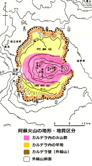
Aso Volcano can be divided broadly into three zones based on differing topographical and geological features: the volcanic group located in the center of Aso Volcano, the plains that extend to the north and south of this volcanic group, and the caldera rim that encircles both the volcanic group and the plains. On this website we refer to these three zones respectively as the "caldera volcanic group" or "central cone group," the "caldera plains," and the "outer rim."
Caldera volcanic group (central cone group)
The caldera volcanic group is comprised of many mountains, including five main peaks called Aso Gogaku, or the Five Peaks of Aso: Mt. Takadake (1,592m), Mt. Nekodake (1,433m), Mt. Nakadake (1,506m), Mt. Kishimadake (1,321m), and Mt. Eboshidake (1,337m). The group includes a diversity of volcanic shapes formed over a wide time span. Among them are stratovolcanos (Mt. Takadake, Mt. Nekodake, Mt. Nakadake, Mt. Eboshidake, etc.), scoria cones (Komezuka), tuff rings (Ike-no-kubo), mud volcanos and fumarolic areas (Yoshioka, Yu-no-tani, Jigoku), and lava domes (the eastern crater basin of Mt. Kishimadake). As a whole the caldera volcanic group is extremely diverse in terms of topographical characteristics, composition, and internal structure. It includes many important geosites where visitors can deepen their understanding of how volcanos are formed.
Located at the approximate center of this volcanic group, Mt. Nakadake has been very active from prehistoric times through the present, and today is one of the few active volcanos in Japan. Fumarolic activity (emission of volcanic gases) continues on a regular basis in the crater even when Nakadake is not erupting, creating a volcanic wilderness zone with a radius of several kilometers in which only a limited variety of specially-adapted shrubs and herbaceous plants grows. The regions surrounding the crater are equipped with instruments for measuring the concentration of volcanic gases and emergency shelters that may be used in case of an eruption. Except during eruptions and when gas concentrations exceed set limits, the crater is safe to observe. Nakadake is one of the few tourist spots of its kind in Japan and attracts many domestic and international visitors. With not only the mouth of the volcano itself but eruptive products, volcanic topography, unique plant life, and extremely rare aeolian landforms (features produced by the wind) to observe, the crater and its surrounding landscape provide an excellent opportunity to gain a comprehensive understanding of volcanic activity, eruptive products, landforms, and vegetation.
Caldera plains
The caldera plains (or floor) stretch to the north and south of the central volcanic group, and are called respectively Asodani Valley and Nangodani Valley. Both are alluvial plains formed by the Kurokawa and Shirakawa river basins. This region is the center of human activity in the Aso region, with many cities, villages, rice paddies, and farm fields throughout. The many springs, artesian wells, and hot springs in the plains provide not only a vital resource for local residents but also recreation and relaxation. Water is the central theme of the geosites in this zone, which includes hot and cold springs; peat bogs and yellow ochre soil that reveal past environmental changes; lacustrine sediments evidencing the past existence of a lake inside the caldera; and waterfalls on the Kurokawa and Shirakawa rivers.
Outer rim of the caldera
Based on geomorphological differences, the outer rim can be divided into two zones: the caldera wall on the inner side, and the slopes on the outer side.
The caldera wall can be further broken down into two distinct sections, one enclosing Asodani Valley in the north, and the other enclosing Nangodani Valley in the south. These sections vary in height, slope, degree of dissection (separation into gorges or crevices), and development of talus and alluvial cones. Overall the more recently-formed northern section includes more unique features. Throughout the caldera wall, pre-Aso volcano rocks most and their covering of pyroclastic deposits are visible. This area features numerous geosites that offer a window into the topography before the formation (collapse) of the caldera, the process and period of caldera formation, and the changes in the topography that took place after its formation. For instance, the natural dikes visible at several locations are not only important geosites for learning about the basic characteristics of this geological feature; they are also key to understanding pre-Aso geology. The talus, alluvial cones, and alluvial fans that develop at the base of the steeply sloped caldera walls provide critical information about the formation of the caldera and its later topographical changes. The springs in the caldera wall serve to deepen our understanding of the topography and geological composition of the wall.
The outer slopes of the caldera rim comprise a gentle plateau which includes undulating landforms, pyroclastic flow plateaus and hills formed from pyroclastic sediments dating for the most part to the caldera's formation. With abundant exposed pyroclastic flow sediment in the gorge walls and bottoms (riverbed), the region equal Japan's finest watersheds, such as the Midori, Kikuchi, Chikugo, and Gokase rivers. The pyroclastic sedimentation in this region includes many sections that welded together when they were hot. For this reason the gorge walls and bottoms have many unique and scenic topographical features created by ignimbrite (a type of pyroclastic rock), including vertical gorge walls with columnar joints; rivers with waterfalls, rapids, deep pools, and potholes; and smooth riverbeds. These geosites offer excellent opportunities for studying the features of pyroclastic flows and their deposits, as well as for understanding the changes that have taken place since the flows were deposited. In addition, the region includes a number of hot springs and tors (high rocky hills), some of which have long been considered by the local people to be dwelling places of the gods.
2.Main geosites
- Aso caldera, one of the world's largest calderas
- Central crater group and neighboring areas
- Nakadake Crater and its activity
- Nakadake Crater area geosites
- Kusasenri-ga-hama and Komezuka area geosites
- Central cone group foothills and caldera lowland geosites
- Outer rim area
- Volcanic activity and religious belief
- Springs
- Miyaji and Yakuinbaru springs
- Minami-Aso Village springs
- Outer rim springs
- Hot springs
- Grasslands and daily life
3.The animals and plants of Aso
- The animals and plants of Aso
- Mammals
- Birds
- Insects [butterflies] [scarab beetles]
- Plants originating on the Asian mainland (species also found on the Korean Peninsula and in northeastern China)
- Plants originating in northern regions
- Plants belonging to the Sohayaki Element. Scientists believe these plants grew in the long-age era when Kyushu, Shikoku and the Kii Peninsula were contiguous.